Robert Jenkin writes:
In 1898 Dutch Scholar J.E.Heeres produced, in Dutch and English versions, an edited edition of the State Archives Copy of the Tasman Journal (SAC) called Tasman’s Journal of his Discovery of Van Diemen’s Land and New Zealand in 1642, with documents relating to his exploration of Australia in 1644.
This work, which includes varied documents and essays, is online. In one important section, Heeres’ essay Abel Janszoon Tasman: His life and labours, http://gutenberg.net.au/ebooks06/0600571h.html#life he argues Gilsemans was probably the expedition’s primary draughtsman (page 107): “As ‘supercargo’ in the Zeehaen we find Isaack Gilsemans. He was most probably the ‘draughtsman’ mentioned in the Instructions, who had been directed to join the expedition”.
A footnote gives two reasons for supposing this, the first a resolution of the Council of the Indies dated August 1st 1642, which notes of Gilsemans that he “has fair knowledge of seafaring and the drawing of lands”, the second a Tasman Journal entry for September 25th reporting that on that day, while at anchor in Mauritius, Visscher and Gilsemans “surveyed the land”. This seems of doubtful relevance since surveying and illustrating may be different things and those two officers may not have been the only ones involved in such activities. Surveys and plans apparently by Gilsemans’ dating from 1635 or 1636 are still extant and do not much resemble any SAC illustrations.
On Heeres authority, and his interpretation of two slender strands of evidence, subsequent historians and archivists have almost universally attributed all illustrations in the SAC to Gilsemans. But Collins, after closely comparing Blok and SAC versions of ‘Murderers Bay’ in 1985, has challenged a related orthodoxy traceable to Heeres’: that the Blok images were copied from the SAC.
In 1642 Schouten instructed Tasman and his senior officers, including Gilsemans about the documentary drawing that needed to be done. He said of the new lands they hoped to find (in Heeres’ translation): “have proper drawings made of their appearance and shape, for which purpose we have ordered an able draughtsman to join your expedition”. Schouten wrote similar instructions for the 1644 Tasman expedition of which Gilsemans was again Upper Merchant: “have proper drawings made of their appearance and shape, for which purpose we have procured an able draughtsman to join your expedition”. The two words ‘able draughtsman’ are Heeres’ English translation of a Dutch word ‘tekenaar’. In both cases what Schouten seems to mean is that a specialist ‘tekenaar’ has been appointed to perform this kind of work, an un-named man, additional to the named officers. “Have proper drawings made” are their instructions, they are not told to do it themselves. It’s also clear an Upper Merchant’s and a draughtsman’s duties could not always be combined. In Murderers Bay the Upper Merchant had neither the time nor opportunity to do the drawing, as I argue here.
In Heeres account of who set out in 1644 he lists those Schouten names, including Gilsemans, then writes: “Besides, there was a ‘draughtsman’ appointed to join the expedition, whose duty it was to map out the coasts, etc. touched at” (Life, p.116). Why is it that in Heeres’ view Schouten’s words mean different things in 1642 and 1644?
In Merchant of The Zeehaen Anderson aligns himself with Heeres on what was meant in 1644: “This suggests that it was not the experienced Gilsemans who carried out this task in 1644, and this time he sailed with Tasman as fully-fledged Merchant, no longer as a humble “drawer of lands“(p.130). This is confusing because Gilsemans held the high rank of Upper Merchant on both voyages. Isn’t it likelier that ‘tekenaar’ referred on both occasions to a person of a lower rank, a ‘petty officer’.
We don’t know all the names or job-descriptions of such officers but one was evidently Hendrik Haelbos who, although unmentioned in Schouten’s instructions or Tasman’s journal’ went on to leave his own published account. His duties seem to have combined those of a ‘barber’ and a ‘wound-healer’. Heeres says he was a ‘naval surgeon’ on board Heemskerck, and since the total complement of both ships was only 110 he might at need have made himself available to Zeehaen too. But Heemskerck as the gunship of the two needed whatever extra hands there were to man her guns. Hoving and Emke estimate she carried up to 20 guns (The Ships of Abel Tasman p.90-91). Her total complement of 60 would have struggled to man half of those in battle and still work the ship. Zeehaen’s whole complement was only 50 but her guns numbered just four (ibid). Heemskerck was therefore likeliest to carry specialist petty officers.
At this link is a 2003 chapter by Deinema on VOC’s chain of command. He states that Upper Merchants were in 1642 top ranking officers: “Until 1742 the senior merchant was theoretically the highest authority aboard a ship, superseded only by the fleet-commander, if several Company ships sailed together.” Apparently not always so in practice, as Gilsemans’ skippers seem to have outranked him first in 1642 and then in 1644: this is attested by their names appearing above his in Schouten’s lists of officers. The petty officers and ordinary crew members aren’t often named in the surviving documents. We only learn the names of three who died in Golden Bay because a sailor, also now anonymous, took time to write them, and his journal was preserved.
Deinema tells how such divisions worked: “First and foremost stood the hierarchical division between major officers, petty officers and ordinary crewmen. A second division pertained more to one’s social status than to one’s position in the ship’s chain of command, namely the division between those housed behind the main mast and those living in front of it. The cabins behind the main mast were the maritime residence of the major officers, the surgeons, the reverend and any official guests traveling on the ship. The infinitely less comfortable and less healthy area in front of the main mast was reserved for the rest of the ship’s inhabitants.” Perhaps an expedition’s ‘tekenaar’ would also have his berth behind the mast: his work at least needed to be as safe and dry as possible.
Anderson writes “My research into VOC records indicates that Isaac Gilsemans, Abel Tasman, and Francoijs Visscher together promoted and planned the voyage in which they all sailed to the antipodes in 1642-43″(p.35) This is a bold assertion but does make some sense. Those three were, with the two skippers, described as “very keen on this discovering” by the Council of the Indies’ August 1st 1642 resolution, and when a further expedition was proposed on January 13th 1644 Tasman and Visscher were again involved and so was Gilsemans.
Between those expeditions it has been suggested Gilsemans helped co-create the set of illustrated day registers pertaining to the first of them. Of these only the SAC is still extant. In Traditional Maori Dress: Rediscovering forgotten Elements of Pre- 1820 Practice (2002) Wallace suggests that at least six of them were made “to send back to the six Dutch provinces that supported the VOC”, and she affirms on Anderson’s authority that Gilsemans writing is identifiable in SAC “in notations in the margins of the pages, and in the similar inscriptions at the top and bottom of each page”(p.41). Anderson also sees the captions on SAC illustrations as Gilsemans’ work. Though neither author claims he copied all the illustrations into SAC, both see him as the designated artist who first drafted them. But documentary and graphic evidence suggests the contrary.
Anderson says of this page from the Huijdecoper manuscript that these are ‘Gilsemans originals’. He adds “there is a lighter touch in his landscape draftsmanship when compared with those copied into the State Archives version.”.
 It is a different style altogether I would say’. Here is a detail from a picture that, as Anderson discovered (Merchant, p.144) was signed by Gilsemans, perhaps in 1635.
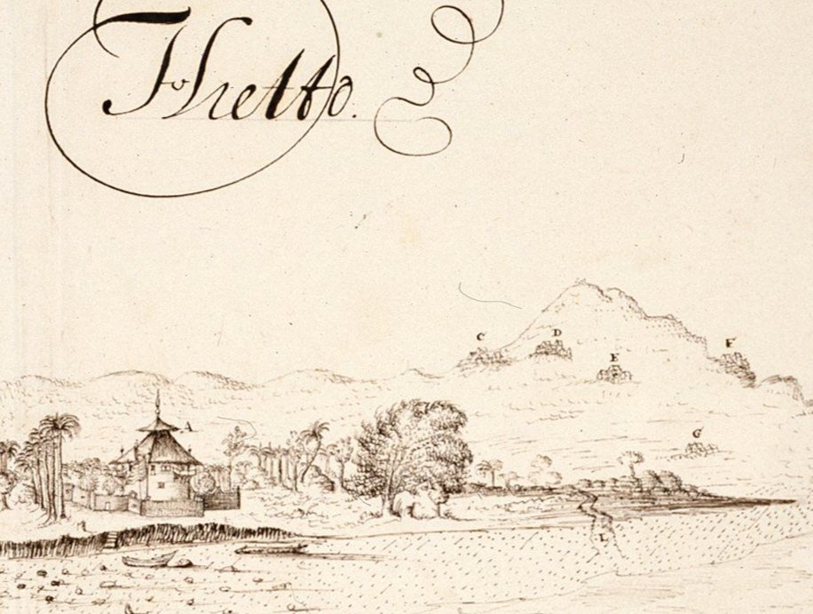 This can be viewed, with over thirty other works that I think are by Gilsemans, at Atlas of Mutual Heritage, where they are helpfully located on a digital photographic map. I will have more to say about them in a later post. Searching on ‘expedition A. Gijsels’ brings them all up.
http://www.atlasofmutualheritage.nl/en/View-Hietto-trading-station-expedition-A.-Gijsels.6505
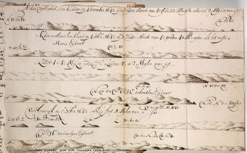
For now I’ll first unpack the coastal drawings shown above, drawings that no one seems to doubt Gilsemans drew, and then compare them with some done on the same two days, presumably by Heemskerck’s draughtsman, which were later copied into SAC. Gilsemans six strip-drawings, once unpacked, become three coastal profiles of different lengths, two drawn during December 4th while sailing roughly north northeast from that morning’s anchorage near South Cape (De Zuijd Cap on the map below) and one the following day before or not long after they turned east.
This detail showstheir course on those two days and is from SAC:
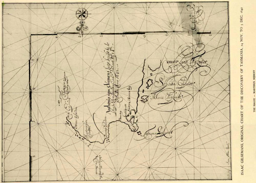
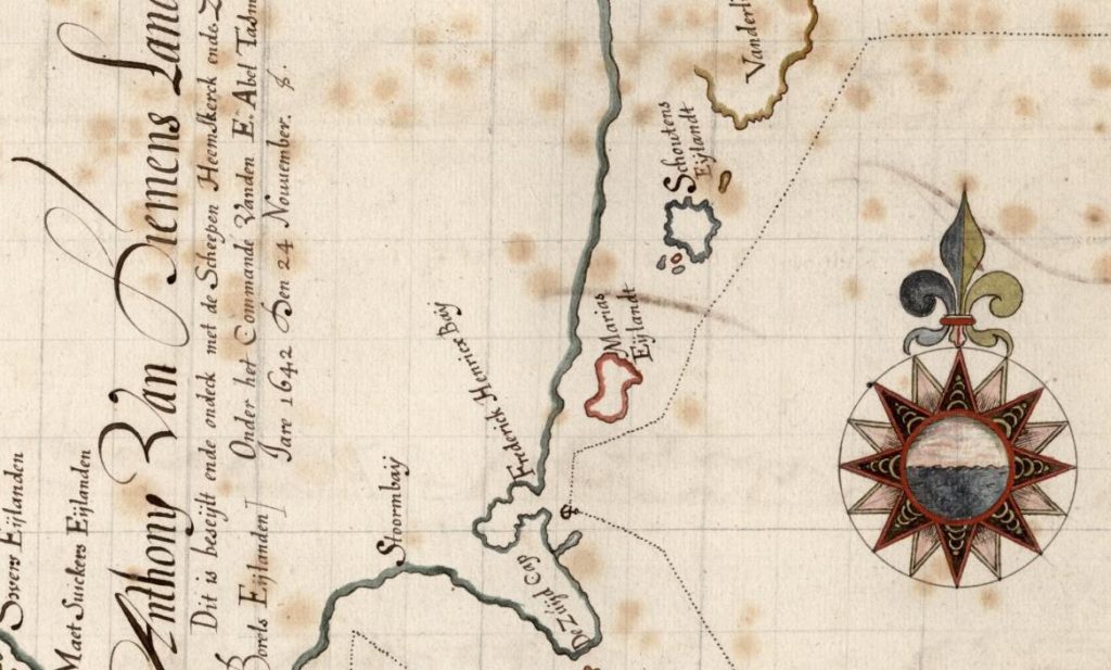 Quite possibly it’s labeling and captions are as Anderson affirms the work of Gilsemans. The map itself may also be, although we have a rather different one signed with his name (top right as it appears below). On this his fine ornate calligraphy seems unmistakable:
Here are his first two coastal profiles, drawn on Dec 4th:
It’s well worth clicking on and then enlarging the second which includes a matching coast profile obtained in Google Earth. Spanning (I think) an arc of about 150 degrees, from what at left I read as southwest by south to what at right I read as north by west, Gilsemans has created a convincing almost modern looking coastal profile. In that respect it’s unlike anything in SAC.
There are some reasons for supposing that the illustrations copied into SAC were drawn at first from Heemskerck and some of these will be presented in a later post. Here is the coast as I suggest the Heemskerck draughtsman drew it on Dec 4th :
 There may be someone who will see a similarity between these profiles and those of Gilsemans, or any correspondence between these and actual features of that coast as seen in Google Earth at all. What I see here are oddly bulbous pinnacles and rows of what seem more like giant rooster combs than hills, combined with ridges more like heaps of shoveled sand.
We know from other illustrations that the Heemskerck draughtsman does have some, and quite specific drawing skills: he’s at his best with people, clothing and anatomy. His coastal elevations generally seem schematic though and even when he wraps them round to make a sort of map inspire little confidence.
 Projections such as these simply do not occur in Gilsemans’ work at Atlas of Mutual Heritage, except where a horizon sometimes curves within 90 degrees. Most of his works seen there have almost flat horizons and are less schematic; with specific details much better observed.
These next two views must both date from Dec 5th, before the two ships sailed east away from their ‘Vanderlin’s Island'( actually a peninsula):
As shown by Gilsemans it’s quite convincing and his landscape modelling is distinctive, as we see below in this ‘View of an unidentified island with five villages on fire’, created probably in the Moluccas during 1635 or 1636:
 There seems good reason to doubt any coastal profiles in SAC are either by him or are copies of his work.
Here are three pairs of coastal views made on Dec 4th and 5th off southeastern Tasmania. Two artists plainly seem to be involved since two quite different styles are in evidence. Would Gilsemans have drawn the three we see to be in his distinctive style and also for some reason drawn three more, in a distinctly different style, which then went into SAC? But all the illustrations in the SAC seem uniform in style and uniformly not to be the work of Gilsemans.
Gilsemans drawing skills were known to his superiors and that is why they mentioned them. But he was one of at least two accompanying artists, and as Upper Merchant drawing was by no means his main responsibility. We have no reason to suppose only one artist was involved; as seen above there are good reasons for supposing otherwise.
The Zeehaen’s Upper Merchant was an artist and he did draw coastal profiles and charts when he had both the time and inclination, as we see above. In fact if only Zeehaen had returned our final illustrated journal of the expedition might indeed have illustrations all by him. But those we do have don’t look like his work, although in some we may detect his editorial influence and all their captions may indeed be his
Since 1898 it has been customary to agree with Heere’s and to attribute every illustration in the SAC to Gilsemans. Today such works as Huijdecoper manuscript and SAC are visually available to anyone who has the internet. Now everyone can be historians it’s time to re-evaluate how many and which people really were involved in making them.

